Cargando...
Recursos educativos
-
Nivel educativo
-
Competencias
-
Tipología
-
Idioma
-
Tipo de medio
-
Tipo de actividad
-
Destinatarios
-
Tipo de audiencia
-
Creador
Lo más buscado
- Juegos de tablas de multiplicar segundo
- Arte bizantino en segundo
- Animales dibujados en tercero
- Letras V
- Actividades de lógica
- Razonamiento verbal
- Animales dibujados
- ejercicios matemáticas imprimir
- Dibujos de Halloween para recortar
- Ejercicios de números romanos
- Horas del reloj
- Letras R
- Actividades de geometría en primero
- Repaso de fracciones
- juegos escolares
-
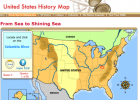
History Map: United States
Tiching explorer Organización
- 2529 visitas
We can read theory and learn maps of the USA from a historical point of the view.
-

Website: StatSilk
Tiching explorer Organización
- 1 lo usan
- 2113 visitas
This webpage offers a range of web-based and desktop software to create interactive maps and graphs.
-
Representing the Earth
EduBook Organización
- 1889 visitas
Globes and maps We use globes and maps to show what the Earth looks like. Globes show the Earth as a sphere. They show the true shape of the Earth and its tilt. They also show the positions of oceans…
-

Weather Forecast & Reports - Long Range & Local | Wunderground| Weather
Perty de Olano Corberó Organización
- 1142 visitas
Weather Underground provides local & long range Weather Forecast, weather reports, maps & tropical weather conditions for locations worldwide.
-
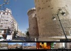
Torres de Quart, València
Cristina Seco Organización
- 542 visitas
Enllaç a Street View de Google Maps a les Torres de Quart, a la ciutat de València.
-
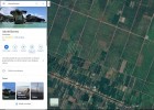
Illa de Borneo
Marta Seco Organización
- 1 lo usan
- 449 visitas
Enlace de Google Maps que nos ofrece unha panorámica xeral desde un satélite da Illa de Borneo.
-
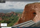
As Médulas
Marta Seco Organización
- 1 lo usan
- 373 visitas
Enlace de Google Maps a través do cal poderemos realizar un percorrido virtual pola paisaxe das Médulas.
-

GoConqr
Esdres Jaruchik Organización
- 288 visitas
Free online Mind Maps maker that lets you visually plot complex concepts and ideas that offer a deeper learning experience.
-
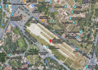
Imagen del Circo Máximo de Roma.
Cristina Seco Organización
- 1 lo usan
- 243 visitas
Imagen de Google maps donde se observa la forma del Circo Máximo de la ciudad de Roma.
-
What is a map?
EduBook Organización
- 1657 visitas
A map is a flat representation of all or a part of the Earth's surface. Symbols represent information on a map. The symbols that appear on a map are explained in the key. Physical maps show natural…


Te estamos redirigiendo a la ficha del libro...
